IBANDA AUTHORITIES DEMARCATE KABOBO WETLAND TO HALT ENCROACHMENT
- Environment
NEWS ROOM
- 0
- 4 minutes read
Ibanda Authorities Demarcate Kabobo Wetland to Halt Encroachment
BY BRIAN MUHEREZA
IBANDA
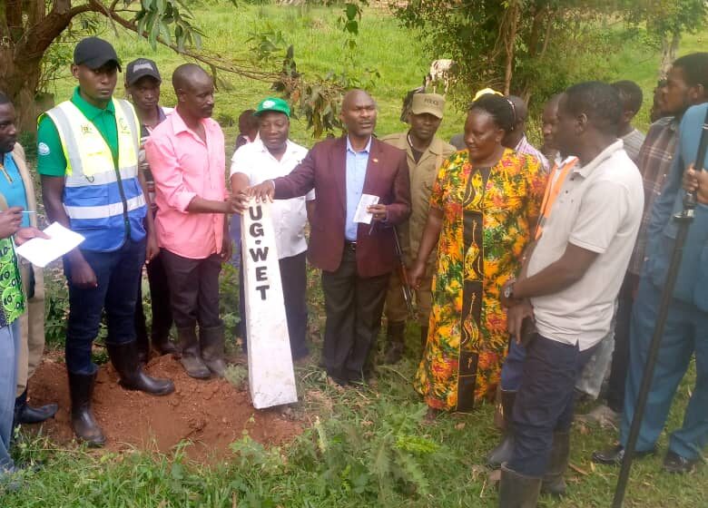
Authorities in Ibanda District, led by the Resident District Commissioner (RDC) and the District Natural Resources Department, have demarcated Kabobo Wetland to curb human encroachment and restore the fragile ecosystem.
The exercise, conducted on Wednesday, involved marking a 30-metre buffer zone from the wetland boundary using concrete pillars.
Kabobo Wetland, located in Igorora Town Council, has in recent years suffered severe degradation from human activities such as grazing, brick making and cultivation.
Speaking during the exercise, District Natural Resources Officer Elly Kilya said the intervention will help reverse environmental damage and protect the wetland for future generations.
“The demarcation is meant to allow the wetland to regenerate naturally. All illegal activities such as grazing, cultivation and brick laying are strictly prohibited within the demarcated area,” Kilya said.
He added that the marked boundaries will provide clarity to surrounding communities and ease enforcement efforts by authorities.
Representing the Ministry of Water and Environment, Albert Kamukama emphasized that wetlands can only be used for environmentally friendly activities that do not compromise their ecological functions.
“People who wish to benefit from the wetland must engage in sustainable activities such as fishing and beekeeping. These are friendly to the environment and do not destroy the wetland,” Kamukama noted.
Ibanda RDC Godfrey Mbetegyerize urged community members to embrace the exercise by respecting the newly demarcated buffer zones.
“Community members must respect the buffer zones that have been demarcated, as protecting the environment is a responsibility we all share,” he said.
Wetland demarcation is a government-led initiative spearheaded by the Ministry of Water and Environment with support from development partners and non-governmental organisations.
The process involves physically marking wetland boundaries using GPS technology, concrete pillars and, in some areas, tree planting as live markers.
The initiative aims to stop further encroachment, restore degraded wetlands and safeguard critical ecosystems that support water security, biodiversity and local livelihoods.
Authorities stressed that community sensitisation remains a key component, particularly in areas where resistance has arisen due to households’ dependence on wetland resources.
Ibanda District leaders have called on residents to cooperate fully with the demarcation exercise, noting that protecting wetlands is vital for sustainable development and climate resilience in the region.